
When planning your next trip to Maine, be sure to take some extra time and see the sights in Piscataquis County. Nature abounds in the region, and the outdoor enthusiast can find many ways to take in the refreshing scenery and behold the beauty. Here are just a handful of Piscataquis County’s most popular destinations.
 Peaks Kenny State Park
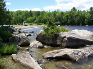
On the shores of Sebec Lake, offering day visitors and campers a peaceful, wooded setting in which to enjoy boating, fishing, swimming, hiking and picnicking. With 56 sites set among stately trees and large glacial boulders near the lake, the campground fosters quiet and private enjoyment of a beautiful natural setting. The 839-acre park is located six miles north of Dover-Foxcroft on the South Cove of Sebec Lake. State Park Reservations Office 207-624-9950 or www.campwithme.com.
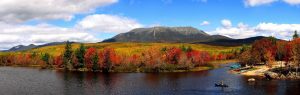
Moosehead Lake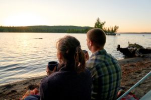
Moosehead Lake, in Greenville, is Maine’s largest lake and is the largest mountain lake in the eastern U.S. The best way to see the lake in its entirety and to enjoy its natural beauty is to take a cruise on the historic Steamboat Katahdin, by seaplane tour or from the summit of one of the area’s many mountains.
Several rivers, such as the Kennebec, West Branch of the Penobscot, Piscataquis, and Moose River, originate in the Moosehead region, making rafting, kayaking, and canoeing popular local activities.
This area is known for its abundant moose population and offers various wildlife viewing opportunities. Experienced Moosehead Lake guides lead safaris where you can safely view moose, bears, and deer, ensuring an enjoyable trip.
Visitors can explore the local towns and villages with boutiques, shops, and restaurants during their trip to the Moosehead Lake Region. For more information, contact Destination Moosehead Lake at 207-695-2702, visit the Visitor Center at 480 Moosehead Lake Road, or the website destinationmooseheadlake.com.
 Mount Kineo
Mount Kineo is a prominent geological feature located on a 1,150-acre peninsula that extends from the easterly shore of Moosehead Lake. Its southeastern face - soaring an impressive 800 feet above water - is the central feature of Mount Kineo State Park, a protected area of 800 acres managed by the Maine Department of Agriculture, Conservation and Forestry.
The state park features four trails that traverse the peninsula and lead to the mountain peak, it also features a remote campground located at Hardscrabble Point. This area is equipped with picnic tables and a small beach and serves as the endpoint of the Carriage Trail.
The Mount Kineo Golf Course, believed to be the second oldest in New England, operates the seasonal (May-October) Kineo Ferry Shuttle from the public dock in Rockwood to Mount Kineo. This well-known landmark is visible when you drive 20 miles north of Greenville along Route 15 to Rockwood. To reach Mount Kineo from Rockwood, you need to take the seasonal ferry. Ferry and trail information is available online or at the Destination Moosehead Lake Visitor Center.
Note: This trail passes over steep cliffs for extended lengths, and adults should be in control of children at all times. Dramatic drop-offs all the way. Watch closely for blaze marks to keep on trail. To take the Bridle Trail to the top, pass the Indian Trail trailhead and continue past a lone cabin on the shore. Immediately behind the cabin is the Bridle Trail trailhead. Or continue on the Carriage Way to Hardscrabble Point where there are signs for the North Trail. Times will vary from 3 to 5 hours depending on route taken.
Borestone Mountain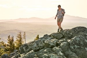
At 1,947 feet, Borestone Mountain is a small but rugged mountain with a bare summit and two peaks. This is a great family hike with interesting nature stations along the trail. Total distance is only four miles.
Directions: Reach the trail by driving south from Greenville on Rt. 15. Take a left on the Elliottsville Road (look for the Appalachian Trail sign). Proceed 8 miles to Big Wilson Falls. Cross over the bridge and take your next left. Cross the railroad tracks.
Trail is approximately .1 miles on the right up a private road. Park on the main road, on the left. A small fee may be charged by the Audubon Society property caretaker.
 Big Moose Mountain
Big Moose Mountain, (formally known as Big Squaw Mountain) rises 3,196 feet and dominates the western view from Moosehead Lake, offering a rewarding experience with stunning views and a challenging ascent. The view from the top encompasses the entire Moosehead Lake Region and its many lakes and mountains.
The first fire tower in the U.S. was built here by M.G. Shaw in 1905 to protect his lumber land. Two miles below the summit, the remnants of the warden’s cabin still exist.
Time: Round trip is approximately 7. 5 miles. Allow up to 5 hours. When on top, proceed a short distance to a ledge with a view of Mirror Pond. There is a 2,000-foot elevation change from the base to the top.
Barren Mountain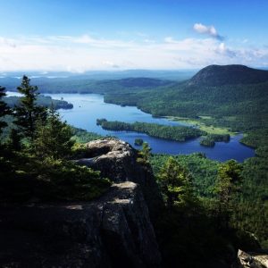
A beautiful, strenuous climb with many unique points of interest. Appalachian Trail and side Trail pass spectacular falls, a gorge, and slide caves. Excellent views in all directions from the summit, an abandoned fire tower. Side trail leads to a remote mountain pond.
Take Elliottsville Road to the bridge and bear right. Go past Borestone Mountain and continue following the dirt road, for 1 ½ miles. Barren Mountain will be in front of you, continue until the road ends. The trail is marked, but take caution, it is not a well-traveled trail since many people do not hike this mountain.
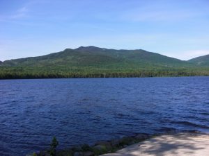
 Mount Katahdin & Baxter State Park
Looming a mile above the northern Maine wilderness, Mount Katahdin (meaning "greatest mountain") stands as a majestic monument to man and nature.
Baxter State Park protects the land because of the foresight and generosity of Percival Baxter. The Katahdin area is a spectacular landform of mountains, river valleys, swamps, meadows, sparkling lakes, forests, boulders, cliffs, serrated ridges, and deep glacial cirques.
An expansive area of alpine flowers and tundra above timberline testifies to the harsh weather of this region, yet more than 100 species of birds and dozens of mammal species, including black bear and moose inhabit the forest.
Lake Hebron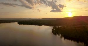
The beautiful shoreline of Hebron Lake is highly developed. There are many private camps and homes situated around the lake. The Town of Monson is located on the southeast shore. The lake is easily accessible by paved road on the north, east and south shores.